Atco Mining Inc. (ATCM.CN)
| Previous close | 0.0250 |
| Open | 0.0300 |
| Bid | 0.0250 x N/A |
| Ask | 0.0350 x N/A |
| Day's range | 0.0300 - 0.0300 |
| 52-week range | 0.0250 - 0.2050 |
| Volume | |
| Avg. volume | 74,617 |
| Market cap | 2.33M |
| Beta (5Y monthly) | N/A |
| PE ratio (TTM) | N/A |
| EPS (TTM) | -0.0100 |
| Earnings date | N/A |
| Forward dividend & yield | N/A (N/A) |
| Ex-dividend date | N/A |
| 1y target est | N/A |
 GlobeNewswire
Standard Uranium Confirms Uranium Mineralization in Multiple Drill Holes at Atlantic Project; Provides Analytical Highlights from Winter Drill Program
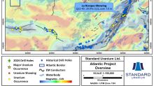
VANCOUVER, British Columbia, June 18, 2024 (GLOBE NEWSWIRE) -- Standard Uranium Ltd. (“Standard Uranium” or the “Company”) (TSX-V: STND) (OTCQB: STTDF) (Frankfurt: FWB:9SU) is pleased to announce a summary of analytical results from the inaugural winter 2024 drill program at its 3,061-hectare Atlantic Project (“Atlantic” or “the Project”) highlighting uranium mineralization in multiple drill holes. Atlantic is situated in the prolific eastern Athabasca Basin, northern Saskatchewan (Figure 1). Th
 GlobeNewswire
Standard Uranium Begins Drilling at Atlantic Project, Eastern Athabasca Basin
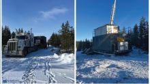
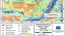
Diamond Drill Rig The diamond drill rig being delivered to the Atlantic project and set up on the first drill hole collar of the winter 2024 program. Figure 1 Regional summary map of the Atlantic Project highlighting nearby uranium occurrences, historical drill holes, geophysical anomalies, and EM conductors. Figure 2 Geophysical map of the western Atlantic claim block, highlighting drill hole BL-16-32 and key geophysical features defining high-priority target areas A and B. Residual gravity-low
 GlobeNewswire
Standard Uranium Mobilizes for Inaugural Drill Program at Atlantic Project, Eastern Athabasca Basin
Figure 1. Regional summary map of the Atlantic Project highlighting nearby uranium occurrences, historical drill holes, geophysical anomalies, and EM conductors. Figure 2. Geophysical map of the western Atlantic claim block, highlighting drill hole BL-16-32 and key geophysical features defining high-priority target areas A and B. Residual gravity-low anomalies are shown at the unconformity depth slice. Target area A will be the focus of the winter 2024 drill program. VANCOUVER, British Columbia,